Design Alternatives
This project will upgrade existing stormwater conveyance, culvert, and ditch systems in the area to alleviate the flooding, erosion, and landslide issues. In addition to these upgrades, the City is considering adding non-motorized improvements along the roadway. The design alternatives considered in a community survey in 2022, along with their associated differential costs, are described below.
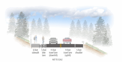
Informed by public input, Council selected Alternative 4 to proceed to 30% design.
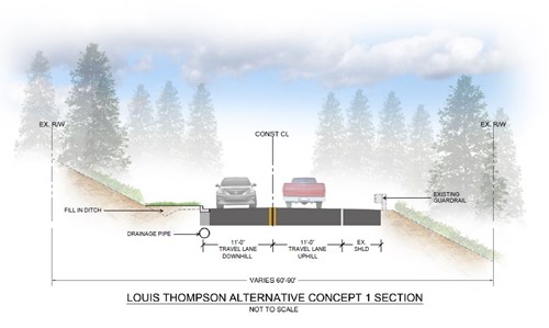
Alternative 1
This alternative proposes only stormwater improvements, mainly along the north (downhill) side of the roadway from 210th Pl SE to 205th Ave NE, to replace the existing ditch/culvert system. The design includes curb & gutter, the stormwater main line with associated structures for runoff collection, and water quality treatment facilities. The existing outfall locations are expected to be maintained.
Baseline cost estimate: $4.5M
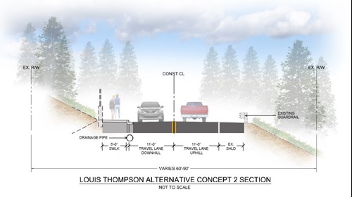
Alternative 2
(Alternative 1 + sidewalk)
This alternative builds on Alternative 1 by adding a 6-ft wide sidewalk along the north (downhill) side of the roadway. The stormwater design is expected to include similar to Alternative 1 elements with the addition of facilities for flow control. This alternative would create the need for some retaining walls to be constructed in order to accommodate the addition of the sidewalk.
Cumulative cost estimate: $6.2M
Alternative 3
(Alternative 2 + rumble strip)
This alternative adds a rumble strip on the south (uphill) side of the roadway. The goal of the addition is to alert drivers every time they cross the fog line in order to protect bicyclists that may be using the existing shoulder.
Cumulative cost estimate: $6.24M

Alternative 4
(Alternative 3 + bike lane)
This alternative adds another non-motorized design element to the proposed cross section, a 5-ft marked bike lane on the north (downhill) side. This alternative would require additional flow control facilities and retaining walls to be constructed based on existing site conditions. This alternative would also potentially impact a number of existing trees.
Cumulative cost estimate: $8.04M
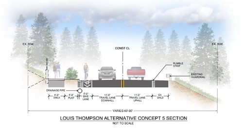
Alternative 5
(Alternative 4 + planter strip)
A 5-ft landscape strip on the north (downhill) side is added for this final project alternative. This cross section is the one closest to the full section by City standards for this type of roadway (with the exception of the median). The wider cross section on the north side of the roadway alignment would require additional retaining walls and result in more impacts to existing trees, when compared with Alternatives 1 through 4.
Cumulative cost estimate: $10.34M